|
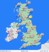 Sunday Sunday
An area of low pressure crosses the UK on Sunday. This takes heavy periods of rain with it, most of it in England and Wales. It also brings strong winds to central and southern parts of England and Wales with gusts of up to 40 mph possible inland, 55 mph along the south coast. Following from the west and north during the afternoon will be sunny spells and scattered showers as well as cooler temperatures. Showers most frequent for north-facing coasts and hills. Highs at 18 or 19C in the south, 12 to 13C elsewhere.
 Sunday Night Sunday Night
Winds will ease through Sunday night as low pressure moves off to the east introducing a northerly airflow across the UK and Ireland. It will be a mostly dry night with varying amounts of cloud around. Light showers are possible for north-facing coasts and hills. Overnight lows at 7 to 11C.
 Monday Monday
Low pressure to the east first thing on Monday morning with cooler air following from the north. Sunny spells for most, a scattering of showers on windward facing coasts and hills. Cloud and rain arriving through southern Ireland, Wales and western England during the morning, then through northeastern England and southern Scotland later in the afternoon and evening. High temperatures at 9 or 10C in northern Scotland, 13 to 17C elsewhere.
 Tuesday Tuesday
Low pressure brings heavy periods of rain through eastern Ireland, Wales and England on Tuesday but clears to the south through the day. Drier and brighter in Scotland, although significantly colder here. Cooler in the south too with strong winds at times. Highs at 14 to 18C in central and southern England and Wales, 8 to 11C elsewhere.
|
