|
 Monday Monday
A ridge of high pressure across eastern England at first on Monday brings a fair start to the day. Fronts will be crossing Ireland and into Scotland as well as the west of England and Wales through the morning bringing periods of rain. This rain then spreads eastwards through the rest of England and Wales during the afternoon. Brighter conditions but with scattered showers follow into Ireland. Windy for all, gales to the west and north. Highs at 7 to 11C.
 Monday Night Monday Night
Rain clears to the southeast of England through the late evening leaving a dry and mostly clear night across the UK. Cloud builds from the west over Ireland and later over western parts of the UK. Rain arrives over northwestern parts of Scotland through the early hours of the morning and spreads quickly across the northern half of the country. Staying windy for northern and western areas with overnight lows at 3 to 7C.
 Tuesday Tuesday
A mild day with strong south-westerly winds affecting all areas. Gales to the north and west. There will be some drizzle over western coasts of Wales, western parts of England and across Ireland. Dry in central and eastern areas but becoming increasingly cloudy here. Heavy rain in central and western Scotland, this rain affecting Northern Ireland and northwestern Ireland too. Highs at 9 to 14C.
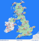
 Wednesday Wednesday
Some rain affecting southern and central England and south Wales on Wednesday. Northern England, Ireland and much of Northern Ireland should be dry and bright too. Rain, sleet and snow in northern and western Scotland. Breezy here too. High temperatures at 4 to 11C, mildest in southeast England.
|
