|
 Monday Monday
Some dense mist and fog on Monday and may be stubborn to lift but most should see some sunny spells about for many, though in the west there will be more cloud and some patchy rain too. Brighter spells eventually developing for some here as the rain attempts to push further east. More rain and strengthening winds moving into western Ireland later. Highs at 10 to 14C.
 Monday Night Monday Night
Outbreaks of rain will progressively move eastwards overnight and by dawn affect many western into central areas, falling heavy for some. The east will be drier though still with places seeing some lingering patchy light rain and drizzle. Lows at 6 to 10C.
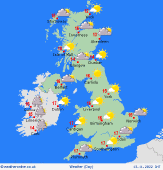
 Tuesday Tuesday
Tuesday sees a cloudy and wet morning with outbreaks of rain, heavy in the west for a time, before clearing many regions of Wales, southwest England and western Scotland as the day progresses to drier and brighter yet cooler conditions here. Staying cloudy and wet further east. A mostly dry and fine day across Northern Ireland. Highs at 10 to 13C.
 Wednesday Wednesday
Low pressure sits northwest of Scotland on Wednesday which will see frequent and at times heavy showers affect western areas. Largely dry further east though some lingering cloud may still be about for a time. As the day progresses spells of rain, falling heavy and persistent in places, and strengthening southerly winds move in to southern England, Wales and south and east Ireland. A cool feeling day with highs at 8 to 13C.
|
