|
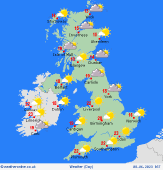 Friday Friday
High pressure north of Scotland again on Friday. Windy conditions continue to affect southern areas of the country. Eastern areas may have some cloud at first but this breaks for many and sunny spells develop. Thicker cloud is expected across southern Ireland and southwest England into Wales where a shower risk is expected. Showers develop as they push north across Ireland with heavy spells expected for some. Elsewhere staying dry. Very warm and humid in the south and west at 22 to 27C, cooler further north and east at 15 to 22C.
 Friday Night Friday Night
Overnight, showers, many heavy and thundery, continue across southwest England, southwest Wales and across much of Ireland where it will also be very muggy. Dry elsewhere with some clear spells. Lows at around 8 up to a humid 15C.
 Saturday Saturday
Heavy, thundery showers as well as longer spells of rain continue to affect much of Ireland into Northern Ireland, parts of southwest England. The showers look to develop and become heavy and likely thundery across parts of Wales into the west Midlands later. Elsewhere will see variable cloud and sunny spells. Best of the lasting sunshine across southeast England. A very warm and humid day for many with highs at 21 to 29C.
 Sunday Sunday
The heavy showers and rain continues northwards on Sunday. Widespread and likely heavy and possibly thundery showers could affect western Scotland as well as Wales. Scattered showers pushing across into northern and central areas of England. Southeast England could also catch some showers later. Many far southern and eastern regions of the UK will remain dry, very warm and the best of the sunshine. Highs at a warm and humid 21 to 28C.
|
