|
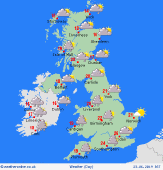
 Saturday Saturday
High pressure in control on Saturday, although the anticyclone is centred to the east of the UK. This allows for a dry morning for most with good sunny spells. However, increased cloud in western parts of the UK and Ireland with the chance of a shower forming over the northern half of the island of Ireland and northeastern Scotland. The afternoon could see some more persistent showers for eastern Scotland and eastern England, isolated showers to the west. Highs at 22C in southern England, 15C in northern Scotland.
 Saturday Night Saturday Night
Showers easing into Saturday night although an area of rain will spread into southwestern Ireland. Scattered showers spreading across Ireland and into northern and western parts of Scotland through the wee hours. Cloud increasing from the west through the night too. Overnight lows widely at 8 to 12C.
 Sunday Sunday
Low pressure to the southwest of Ireland, higher pressure to the north of the UK. Further cloud and rain edging into southern Ireland, Wales and western England through the afternoon. A few showers in western Scotland. Drier elsewhere, some good sunny spells in the east. Highs at 24C in the south, just 14C in northern Scotland.
 Monday Monday
Low pressure over Ireland on Monday. A front moving north and east brings rain, this heavy in Scotland. Slowly turning drier to the south as the rain and showers fade. Warmer air wafts north and it will feel muggy. Thundery showers possible later in the southwest. Highs at 27C in southern England, 13 or 14C in northern Scotland.
|
