|
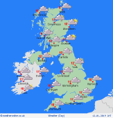 Sunday Sunday
High pressure remains to the southwest of Ireland on Sunday while low pressure is over Scandinavia. This brings a brisk northwest wind affecting most places, with gales for the northern half of the country. Strong gusts are possible everywhere. It will be another largely overcast day with prolonged outbreaks of rain for northern and western areas. The best chance of any brightness will be in eastern Scotland and northeast England. High temperatures at 7C in Scotland, 8C in Northern Ireland and 9 to 11C elsewhere.
 Sunday Night Sunday Night
Clear skies overnight for eastern and southern Scotland and the north of England. Broken cloud everywhere else. Light rain or drizzle will continue in the northwest of Scotland but winds will ease as the night goes on. Temperatures will fall to 0 to 5C.
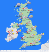
 Monday Monday
An area of high pressure is centred to the southwest of the British Isles while an area of low pressure is centred to the northwest and extends a trough eastwards, to the north of Scotland. It will be a cloudy day in the north and west with spells of rain in western parts of Scotland and Ireland. Drier and brighter to the east and south. Highs at 6C in Scotland, 7C in Northern Ireland and 8C in England and Wales.
 Tuesday Tuesday
An area of low pressure is centred to the north of Scotland on Tuesday. It will be a cloudy and windy day in the north with prolonged spells of rain for the Northern Isles and northwestern Scotland. Rain will also affect northwestern parts of Ireland later in the afternoon as a front moves in from the Atlantic. A drier and brighter day in the south and east though there may be some low cloud around the south coast of England throughout the day. A milder day everywhere with highs at 8C in Scotland, 9C in Northern Ireland and Wales, and 10C in England.
|
