|
 Tuesday Tuesday
High pressure is centred to the east of Britain, promoting a southeasterly airflow across the country into midweek. Light winds overall, although southwestern coasts may be breezier. A lot of sunshine, a slight haze. Some localised mist patches forming from dawn. Highest temperatures toward the north and west in shelter to the lee of the hills, widely 14 to 19C, locally 20 to 22C in northeast Scotland. Cooler near coasts.
 Tuesday night Tuesday night
High pressure stays to the east bringing a dry night for the UK and Ireland. Some high cloud may linger through the night, particularly in the west. Clearer skies in the southeast. Some localised mist or fog patches forming once more. Overnight lows at 4 to 9C for most, milder on coasts.
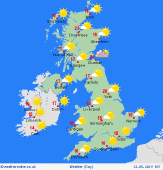
 Wednesday Wednesday
High pressure stays northeast of the UK. A slack southeasterly pattern prevails. Dry and sunny overall, perhaps a slight haze toward the south and east. Light winds for most, but a brisk easterly on the south coast. Some high cloud may come into Ireland. Starting cool with local mist patches and a touch of frost rurally. Highs widely at 15 to 19C, locally topping 20 to 23C in favoured spots in the north & west.
 Thursday Thursday
High pressure over Scandinavia brings an east to southeasterly air flow to the UK and Ireland. A dry and bright day for eastern areas on Thursday; cloudier in the west with a chance of showers developing through the afternoon. High temperatures at 14 to 18C.
|
