|
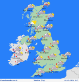
 Monday Monday
The cold theme continues into Monday and with a brisk easterly wind it will feel bitterly cold in areas exposed to the wind. Frequent snow showers blow in across eastern and northern Scotland, eastern England and into eastern parts of Northern Ireland and Ireland too. Snowfall is looking likely it will continue to affect far southeastern parts of England. The best of the sun to the northwest. High temperatures at just -2 to 3C colder when adding on the chill factor.
 Sunday Night Sunday Night
Overnight, snow will continue to fall across eastern areas mainly, but reaching some western regions too. Clearer skies towards the west and northwest. Severe widespread frosts are expected as overnight lows dip to -4 to -1C for most, much colder in more sheltered and rural spots.
 Tuesday Tuesday
Another cold day on Tuesday with a brisk easterly wind. There will be further snow flurries affecting eastern parts of Scotland and the north of England as well as eastern northern Ireland. The best of the sun to the northwest once again. Meanwhile, an area of low pressure in the Bicay will allow for cloudier skies across the far south of England and the risk of some rain, sleet and snow to coastal areas. Highs at a very cold -3 to 2C and feeling colder in the wind.
 Wednesday Wednesday
Wednesday will continue to be cold and feeling bitter in an easterly wind still. High pressure becomes more dominant today allowing for mainly dry weather across the UK and bright conditions towards the west, although light snow flurries and cloudier skies will continue across easternmost areas. A broad area of Atlantic low pressure is waiting in the wings and will strengthen winds across Ireland and Northern Ireland through the day. High temperatures at a chilly -2 to 3C, but feeling even colder in that easterly wind.
|
