|
 Tuesday Tuesday
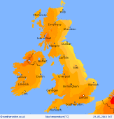
Most places are likely to stay dry. Sunshine best in the west and north-west. Low cloud may linger around North Sea coasts in the north-east. Localised thundery downpours are likely to affect southern England and the English Channel throughout the day, drifting westwards. Further storms may move into the south-east by evening. A general east to north-easterly breeze. Around 15C or below on eastern coasts, 20 to 23C in central areas, up to 25C around London, also western Scotland.
 Tuesday night Tuesday night
Many areas will be dry through the night. A risk of thunderstorms affecting the far south and south-east - these may give bursts of rain for a few hours, plus frequent lightning. Murky toward the north-east. Clear skies for many. Local mist patches in some low-lying areas. Light winds from the east or north-east. Temperatures 8 to 12C, locally cooler some rural northern areas.
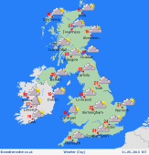
 Wednesday Wednesday
Clusters of thundery showers are expected to drift westwards across central England and Wales. This may merge into a more organised zone of heavy rain for several hours. A few bursts also possible for Scotland. Low cloud is likely to affect north-eastern coasts. Best of the sunshine in western Scotland and Northern Ireland. An easterly breeze in the north, light winds south. Highs 15 to 18C east, 20 to 23C central and western areas.
 Thursday Thursday
Staying generally warm and humid with a risk of thunderstorms. The greatest risk of downpours is across central and southern parts of Britain and Ireland, with some slow-moving torrential bursts possible into the afternoon and evening. An easterly breeze across Scotland, otherwise very little wind. Gusty locally around showers. Sea breezes near coasts. Max temperatures 21 to 24C inland, but just 14 to 17C coasts.
|
