|
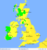
 Sunday Sunday
A cold front brings a band of rain through Ireland on Sunday morning. The rain then reaching western Scotland, western Wales and western England by late morning, before tracking across the rest of Scotland, northern, central and southern England as a much weakened feature in the afternoon. A drier and brighter start in central and eastern parts. Becoming windy in the west with brighter weather and some heavy showers following for Ireland. Highs at 9 to 14C.
 Sunday Night Sunday Night
A mixture of cloudy and clear skies overnight from Sunday to Monday. Clearer skies to the north and west, cloudier in the south and east. Some light rain or drizzle could persist for western areas. Staying windy in the northwest. Overnight lows of 4 to 8C.
 Monday Monday
Weak fronts edge slowly southeastward across the UK on Monday.These will bring cloud to northwestern and southeastern areas and some light rain to Ireland, northern and western Scotland, Wales and much of England with the exception of the northeast. The best of the brightness will be for eastern Scotland and northeast England. Windy in the north. High temperatures at 7 to 11C.
 Tuesday Tuesday
A ridge of high pressure may build across the country early on Tuesday though a frontal system will bring cloud and rain to western areas later in the day. This allows for some morning mist and fog patches and perhaps an early frost before cloud builds from the west. Light rain will reach most of Ireland and Scotland, northwestern England and north Wales through the afternoon. Breezy in the west. Highs at 7 to 10C.
|
