|
 Thursday Thursday
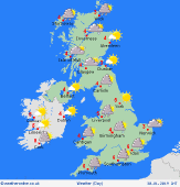
Low pressure to the southwest of Ireland will push fronts north and east through Thursday. This brings some heavy rain to southern Ireland and the far southwest of England in the morning but it will be a dry, bright, frosty and icy start everywhere else. As the rain moves north and east across Northern Ireland, Wales, the Midlands and southern England in the afternoon it will turn increasingly to sleet then snow. Most over high ground, but some eventually falling at lower levels too. There could be gales too for a time for southern Ireland and southwestern parts of England and Wales through the afternoon. Scattered snow showers in northern and eastern Scotland but for most of Scotland it should be a dry day with plenty of sunshine. Fine and sunny for much of northern England and eastern England as well. High temperatures at 2 to 5C.
 Thursday night Thursday night
A cloudy night for the southern half of the country as low pressure stays close by to the south west. Clear skies over much of Scotland. Snow will persist through the night for the southern half of Ireland, much of Wales and England too. Rain is expected for coastal parts of Ireland and the southwest of England. Some light snow showers too for northwest Scotland and the Northern Isles. Overnight low temperatures falling widely to -4 to 1C.
 Friday Friday
Low pressure lies close to the south coast of England on Friday. Fronts wrapped around the low will be bringing periods of rain, sleet and snow into Ireland, Wales and much of England overnight into Friday. This may allow for a period of several hours of snow for the southern half of England and much of Wales. However there still remains some uncertainty in this at the moment. Snow showers in northern Scotland, otherwise mostly dry. Highs at 5C in southern England, more widely 1 to 3C.
 Saturday Saturday
Low pressure to the east and a ridge of high-pressure building to the west through Saturday will lead to a cold, northerly airflow over the UK and Ireland. It will be a very cold start to the day away from southeast England with a widespread frost and icy patches expected. It should be a bright and dry day for most though there will always be a chance of wintry showers for coasts exposed to the northerly wind, particularly in the east. A cold day with high temperatures at 0 to 5C.
|
