|
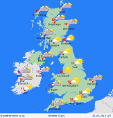
 Sunday Sunday
A cold front eventual clears southern England on Sunday morning, taking spots of rain with it. Turning brighter for most as a ridge of high pressure builds through Ireland, England and Wales allowing for sunny spells. Breezy in Scotland with showers here, most of them in the north and west. These will likely be wintry in nature over the hills. Showers may affect Northern Ireland and the north of England too through the afternoon. Drier and brighter in eastern and southern Scotland. Highs at 13C in southeast England, 7 to 10C in the north and west.
 Sunday Night Sunday Night
Showers easing over Scotland through the night though they may linger over Northern Ireland and Wales through the early hours of Monday morning. It will be a mostly cloudy night with the exception of eastern parts of Scotland and England where skies will be clearer. Winds easing for Scotland overnight. Low temperatures falling to -1 to 4C.
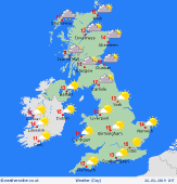
 Monday Monday
High pressure is centred over the Irish Sea on Monday and is affecting all of the UK and Ireland. It will be a cool day but dry with plenty of sunshine. There may be a few mist and fog patches around first thing but these should burn off quickly. High cloud may turn the sun hazy at times while northern areas may remain cloudy for much of the day. Highs at 8 to 13C.
 Tuesday Tuesday
High pressure remains centred over southern England on Tuesday affecting the UK and Ireland. It is likely to be a chilly start to the morning with a few mist and fog patches possible. The day is likely to be dry and sunny over most of England, Wales and Ireland as well as southern and eastern Scotland. Some cloud in northwest Scotland allowing for a few spots of drizzle here. Highs at 9 to 14C.
|
