|
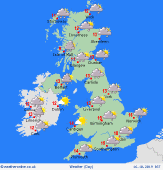
 Tuesday Tuesday
Some rain in eastern England at first on Tuesday. This is going to be clearing in the morning to leave much of eastern England with a fair amount of cloud, although a few bright spells developing. Brighter to the west and south with sunny spells for most although an area of showers developing in southern England, pushing into south Wales and the Midlands as wel as East Anglia. Ireland will have increasing wind and cloud with some rain in the far west later. Highs at a mild 17C in the southeast, 12C in central Scotland.
 Tuesday Night Tuesday Night
Becoming wet tonight in Ireland with some heavy rain affecting southern areas. For the Uk it should be drier with clearer spells, although rain will be arriving in Northern Ireland in the early hours. This rain then moves into Wales and southwest England by the morning. Eastern areas tending to be drier. Lows near 9 to 13C.
 Wednesday Wednesday
A front brings rain to much of Scotland and England on Wednesday morning. The rain could be heavy at times as it moves eastwards. Drier and brighter weather, although with some showers follows ino the west of the UK and affects the whole of the island of Ireland throughout the day. Most of any showers in Ireland in the west. Tops at 17C in East Anglia and the southeast, becoming colder from the west as the brighter weather arrives with 11 to 13C.
 Thursday Thursday
A deep area of low pressure to the west of Ireland on Thursday. An occluded front will be bringing rain and cloud to much of Ireland and western Scotland with windy weather here too. A trough brings showers to Wales and southern England. eastern parts of England and eastern Scotland should be drier and brighter at first, although showers could occur here later. Highs at 11 to 15C.
|
