|
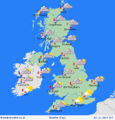
 Sunday Sunday
A chilly start to the day on Sunday with higher pressure to the west and lower pressure to the south and east. A widespread frost and ice patches forming. Some showers around northern and western coasts of Scotland and eastern coasts of Scotland and England; these turning wintry over higher ground in Scotland. Showers too for the Northern Isles. Good spells of sunshine elsewhere with high temperatures at 1 to 7C.
 Sunday Night Sunday Night
Cloud builds over Scotland through Sunday night into Monday morning and fronts bring outbreaks of rain to the northern half of Scotland and the Northern Isles. Mostly clear skies elsewhere will allow temperatures to tumble and a widespread frost and ice patches to form. Overnight lows of -1 to 1C for most, milder for Scotland at 2 to 6C.
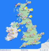
 Monday Monday
High pressure is centred over Ireland and extends over much of the UK. A mostly dry day with sunny spells, although the threat of isolated mist and fog patches at first as well as a widespread frost. Cloudier over Scotland with outbreaks of rain for northern areas. Highs at 4 to 7C.
 Tuesday Tuesday
High pressure centred over the south of the UK and Ireland on Tuesday. A southwest wind brings more cloud into Scotland. Some low cloud over northwest coasts of England too. Some mist and fog in Wales and other areas of England, lifting to give some sunny spells here. Highs at 4 to 7C.
|
