|
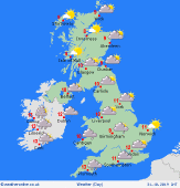 Friday Friday
A complex series of fronts move across the British Isles. A spell of rain drifts east and northwards in the morning, likely to persist across Scotland much of the day. Clusters of heavy showers are likely to follow from the west, risk merging back into constant rain. Some drier conditions across central England & Wales for a few hours. Risk of strong or gale force winds around southern coasts. Temperatures between 8 and 16C, mildest in the far south.
 Friday night Friday night
Bands of rain continue to push eastward across the country through Friday night and into Saturday morning. It will become briefly drier over much of England, Wales and southern Scotland before further rain moves in from the west. A very windy night for Ireland and the southern UK with gales here and to the far north. Overnight lows at a milder 6 to 11C.
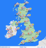 Saturday Saturday
Confidence of precise detail is low, but generally unsettled conditions are expected. Low pressure centred toward the southwest is likely to push bands of rain northeastwards, setting in heavy for several hours, whilst some places will remain dry for several hours too. Blustery winds, risk of gales, particularly in the south. Highs 7 to 12C.
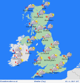 Sunday Sunday
Low pressure continues to dominate, with various separate centres circulating around the British Isles, making detail very uncertain. Expect areas of persistent heavy rain, but also some drier spots for at least part of the day. Windy, gales in places, especially around southern coasts. Highs 6 to 12C.
|
