|
 Tuesday Tuesday
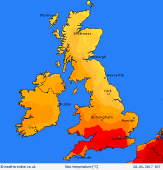
A weak frontal zone lies across central regions, producing a rather cloudy day for many, and less hot than previous days, around 22 to 25C. Low cloud and murk may persist for eastern England whilst cloud is likely to break toward the west. South & south-west England may be hot again at 29C. Isolated thunderstorms possible for south Wales & the south Midlands. Northern Britain stays dry with sunny spells and little wind, 17 to 21C.
 Tuesday night Tuesday night
A humid night for many as a warm front advances back northwards, with murky conditions in the west & south - fog likely for coasts & hills in the south-west and near the Irish Sea. Areas of rain, possibly thundery, are likely to break out across Ireland and push north before dawn into southern Scotland & northern England. Likely staying dry for much of Wales, the Midlands, south & east of England. Lows 10 to 13C north, 14 to 18C south.
 Wednesday Wednesday
Areas of rain and possible thunderstorms move north-east across Scotland, perhaps northern England. Bursts of rain also breaking out for Wales and parts of Ireland, although some places staying dry. Murky and dull for the west & north, with extensive low cloud. Coastal fog in the south-west. Central & south-eastern England should stay dry with hazy sun and feeling very humid. Temperatures 19 to 23C north, 25 to 30C Midlands & south.
 Thursday Thursday
A cold front passing slowly east across central-southern Britain brings a risk of thundery bursts of rain - timing uncertain. Ahead of this zone, south-east England could see a very hot and humid day with hazy sun. Behind the front in the north & west, expect fresher conditions with variable cloud and a few showers. Breezy in the north-west. Temperatures 16 to 21C north & west, 24C Midlands, perhaps topping 30C in south-east.
|
