|
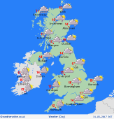 Saturday Saturday
A trough of low pressure influences the country, triggering areas of heavy showers throughout the day. These mostly affect western areas in the morning - some locally persistent rain. Showers will break out more widely by the middle of the day, and by afternoon, will be most widespread across central & eastern areas. Isolated thunder. Some sunshine, best in the east early morning. Winds fairly light. Temperatures 11 to 15C.
 Saturday night Saturday night
Showers will fade from eastern regions in the evening and all regions will become dry as pressure builds from the west. Clearing skies will allow temperatures to drop away, resulting in a rural grass frost by dawn on Sunday. Low lying mist patches may form as winds drop light, but these will soon clear in the morning. Lowest temperatures 0 to 3C in rural parts, coldest north & west. Nearer 3 to 5C in towns and cities.
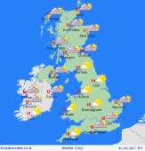 Sunday Sunday
High pressure extends across the country, bringing a dry day to all regions. Plenty of bright sunshine. Fair weather cloud will tend to build through the day. Later, high cloud will thicken across western Britain & Ireland ahead of fronts moving in from the Atlantic, bringing rain to the far west overnight. A southerly breeze will also freshen in the west. Otherwise winds will be light and variable. Top temperatures 11 to 15C.
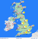 Monday Monday
High pressure influences south-eastern Britain, and brings a fine day for much of England & Wales. Sunshine turns hazy, then increasingly overcast from the west later as fronts move in from the Atlantic. Rain extends across Ireland and into western Scotland, most persistent over the hills. Patchy rain reaches Irish Sea coasts later. A freshening southerly breeze, strongest in the west & north. Highs 11 to 17C, warmest south-east.
|
