|
 Tuesday Tuesday
A weakening cold front lies across central England & Wales, bringing cloud and patchy light rain in the morning, but cloud should slowly break up to give some sunshine. Bright and breezy with sunny spells in the north and west. Showery in western Scotland & Northern Ireland, locally heavy and frequent rain for the northern Highlands. Warm and humid with light winds in the south-east, up to 25C, but fresher at 16 to 20C for most.
 Tuesday night Tuesday night
A shallow area of low pressure over northern France may push some rain close to south-east England in the early hours, but most places will stay dry overnight. Breezy in the north, with showers in western Scotland. Clearing skies for many areas in the north & west, but the south-east is likely to stay cloudy. Lows 12 to 15C south-east, 10 to 12C central areas, but dipping to 7 or 8C north & west, locally 5C rural Scotland.
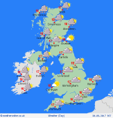 Wednesday Wednesday
Slack pressure across the British Isles and the remnants of previous fronts may result in a generally cloudy day. Outbreaks of rain or drizzle possible, but may amount to very little for many places. However, locally across central areas, a chance that rain may linger for several hours. Bright and breezy in the north, with frequent showers for western Scotland, and scattered showers elsewhere. Just 15 to 19C, but locally warmer south.
 Thursday Thursday
Pressure is likely to build slowly from the south-west. A bright day, although there will be scattered showers, mainly for northern & western areas, locally heavy, passing eastwards through the day, and tending to fade from the west. Perhaps very few showers in the south & east of England. Sunny spells. A moderate westerly breeze, and feeling fresh. Starting cool. Top temperatures 16 to 20C, up to 22C in the east.
|
