|
 Saturday Saturday
Fronts will push northwards, bringing persistent rain and brisk easterly winds to Scotland - snow for the Highlands. Heaviest falls toward the east. Early rain in north & eastern England will clear. Central areas stay dry much of the day with sunny spells. Winds touching gale force in the south-west, where showers will become frequent and extend across Wales by afternoon. Frequent bursts of rain for Ireland. Highs 7 to 11C.
 Saturday night Saturday night
Rain and snow will slowly fade for Scotland into the night, although the far north may remain wet into the early hours. Showers will drift across north Wales into north-west England. Further fronts moving in from the Atlantic bring persistent rain back across Ireland and toward the south-west before dawn. Central, east & southern Britain should be dry with clear spells and local frost. Breezy in the south. Lows 0 to 5C.
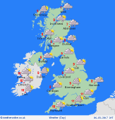
 Sunday Sunday
Low pressure remains in charge. Fronts extend eastwards across the southern half of Britain during the day, bringing rain for several hours to much of England & Wales, heaviest toward the south-west, whilst the north-east may escape largely dry. Scotland should see a brighter day, although showers are likely in the east. Rain on and off for Ireland. Gales around coasts in the south-west. Light winds in north. Highs 7 to 10C.
 Monday Monday
A slack pressure regime influences the British Isles, whilst a small low is likely to pass from the south of Ireland into northern France. This may bring persistent rain to south-western Britain. Elsewhere, expect a scattering of showers, tending to move around slowly in light winds. However, there will also be plenty of dry weather, with sunny spells. Starting cool with local frost. Highs 7 to 11C.
|
