|
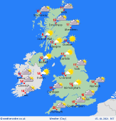 Saturday Saturday
High pressure is pushed towards the near continent on Saturday. A chilly start again, perhaps even for some central areas compared to Friday. The day itself will see alot more cloud about but it should be mainly dry, although with some patchy light rain and drizzle over western and southern coasts and hills. Misty here too. Eastern areas seeing the best of any sunny spells. More persistent rainfall expected to push in across Ireland and Northern Ireland later in the day. Highs at 12 to 16C, mildest in the west.
 Saturday night Saturday night
Rain spreads in across much of Scotland, northern into central areas of England and far northern parts of Wales overnight. Rain clearing western regions of Ireland later on. Staying dry elsewhere though cloudy. A milder night with lows for most between 7 and 14C though cooler across northern Scotland.
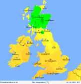
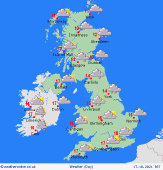 Sunday Sunday
Another largely cloudy day in a moist southwesterly flow. Outbreaks of rain affecting many northern and central regions of the country through much of the day. Perhaps some good sunny spells across parts of southern England and Wales where it should remain dry. Rain looking to turn light and patchy for many in the afternoon. Highs at a milder 12 to 17C for most though cooler still across parts of northern and central Scotland.
 Monday Monday
Heading into the new week expect an unsettled weather pattern to move in though it will remain unseasonably mild. Spells of rain will push eastwards as fronts move across the country along with a strengthened south-westerly wind. Rain heaviest to the north and west while turning rather patchy across England. A mild day with highs at 12 to 18C.
|
