most recent model run
Région - NAVGEM - Nouvelle-Zélande
Paramètre - NAVGEM - V-Adv. 500 hPa
Modèle
NAVGEM Modèle - V-Adv. 500 hPa Nouvelle-Zélande - Info
0
3
6
9
12
15
18
21
24
30
36
42
48
54
60
66
72
78
84
90
96
102
108
114
120
126
132
138
144
150
156
162
168
174
180
V-Adv. 500 hPa NAVGEM Modèle
Modèle:
NAVGEM (Navy Global Environmental Model) is a global numerical weather prediction computer model run by NOAA. It replaced NOGAPS as the prime model in the middle of February 2013 at the FNMOC Weather model synoptic site. NOGAPS: Global weather forecast model from the "Fleet Numerical Meteorology and Oceanography Center" (USA)
Mise à jour:
2 times per day, from 10:00 and 23:00 UTC
Greenwich Mean Time:
12:00 UTC = 13:00 CET
Résolution:
1.0° x 1.0°
Paramètre:
Geopotential in 500 hPa (solid, black lines) and Vorticity advection in 105/(s*6h) (colored lines)
Description:
The two types of vorticity advection are positive (PVA) and negative vorticity
advection (NVA). 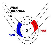 The closed circles in the figure show the 500 hPa absolute vorticity
lines, the others the 500 hPa height lines. When an air parcel is moving from
an area higher vorticity to an area lower vorticity this is called: PVA
(red color). The other way around is called: NVA (blue color). PVA is
associated with upper-air divergence, i.e. upward vertical motion. NVA
is associated with down ward vertical motion. Therefore, PVA at 500
hPa is strongest above a surface low, while NVA at 500 hPa is strongest
above a surface high.
The closed circles in the figure show the 500 hPa absolute vorticity
lines, the others the 500 hPa height lines. When an air parcel is moving from
an area higher vorticity to an area lower vorticity this is called: PVA
(red color). The other way around is called: NVA (blue color). PVA is
associated with upper-air divergence, i.e. upward vertical motion. NVA
is associated with down ward vertical motion. Therefore, PVA at 500
hPa is strongest above a surface low, while NVA at 500 hPa is strongest
above a surface high.
In operational meteorology Vorticity advection maps are used to identify areas with vertical air motion to see where clouds, precipitation or clear conditions are likely to occur. Keep in mind, however, that PVA is not the same as upward vertical motion. Here temperature advection is important too.
 The closed circles in the figure show the 500 hPa absolute vorticity
lines, the others the 500 hPa height lines. When an air parcel is moving from
an area higher vorticity to an area lower vorticity this is called: PVA
(red color). The other way around is called: NVA (blue color). PVA is
associated with upper-air divergence, i.e. upward vertical motion. NVA
is associated with down ward vertical motion. Therefore, PVA at 500
hPa is strongest above a surface low, while NVA at 500 hPa is strongest
above a surface high.
The closed circles in the figure show the 500 hPa absolute vorticity
lines, the others the 500 hPa height lines. When an air parcel is moving from
an area higher vorticity to an area lower vorticity this is called: PVA
(red color). The other way around is called: NVA (blue color). PVA is
associated with upper-air divergence, i.e. upward vertical motion. NVA
is associated with down ward vertical motion. Therefore, PVA at 500
hPa is strongest above a surface low, while NVA at 500 hPa is strongest
above a surface high. In operational meteorology Vorticity advection maps are used to identify areas with vertical air motion to see where clouds, precipitation or clear conditions are likely to occur. Keep in mind, however, that PVA is not the same as upward vertical motion. Here temperature advection is important too.
NWP:
La prévision numérique du temps (PNT) est une application de la météorologie et de l'informatique. Elle repose sur le choix d'équations mathématiques offrant une proche approximation du comportement de l'atmosphère réelle. Ces équations sont ensuite résolues, à l'aide d'un ordinateur, pour obtenir une simulation accélérée des états futurs de l'atmosphère. Le logiciel mettant en œuvre cette simulation est appelé un modèle de prévision numérique du temps.
Prévision numérique du temps. (2009, décembre 12). Wikipédia, l'encyclopédie libre. Page consultée le 20:48, février 9, 2010 à partir de http://fr.wikipedia.org/w/index.php?title=Pr%C3%A9vision_num%C3%A9rique_du_temps&oldid=47652746.
Prévision numérique du temps. (2009, décembre 12). Wikipédia, l'encyclopédie libre. Page consultée le 20:48, février 9, 2010 à partir de http://fr.wikipedia.org/w/index.php?title=Pr%C3%A9vision_num%C3%A9rique_du_temps&oldid=47652746.

Times:
available
selected
available (previous base)
not available