|
 Wednesday Wednesday
A bright day for central & southern Britain. Sunny spells, best in the south-east. A strong westerly wind, particularly in the north, gusting over 60 to 70mph in exposure and over higher ground. A few wintry showers affect north-west England & Wales. Showers will be very frequent in western Scotland, becoming heavy, with hail, or snow to increasingly low levels. Temperatures 4 to 8C, perhaps briefly higher in the south.
 Wednesday night Wednesday night
Strong to gale force westerly winds continue across northern Britain. Clusters of showers affect the north-west, merging into bands of frequent snow or hail locally, and may give local significant accumulations of snow in west & south-west Scotland. Wintry showers also developing for west Wales & the south-west. Largely dry in central, southern & eastern Britain. Temperatures 0 to 3C.
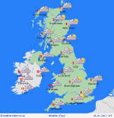
 Thursday Thursday
Frequent heavy showers in west & north-western Britain & Ireland. These will fall to low levels as snow or hail, giving possible accumulations and possible disruption to travel. Isolated thunder, particularly near coasts. A band of rain and hill snow also threatens the south-west. Mainly dry with sunny spells in the east. Highs 2 to 6C - bitterly cold in strong to gale force westerly winds.
 Friday Friday
Low pressure over Scandinavia and high pressure to the south-west. A cold day for all regions. Areas of snow showers, most frequent around coasts in the north & west, perhaps also eastern England. Some bands of snow may extend into the Midlands from the north-west. Otherwise, plenty of sunshine, and many inland areas may remain largely dry. A north-westerly breeze will feel very cold. Highs 0 to 4C.
|
