|
 Friday Friday
A bright and breezy day for most places, with broken cloud and good amounts of sunshine, generally best in eastern areas in the morning, then around many coasts into the afternoon. Expect scattered light showers almost anywhere, but moving through quickly on the wind. A front across northern Scotland brings frequent rain to the Highlands. Winds tending to ease a little. Top temperatures 15 to 18C north & west, 19 to 22C south & east.
 Friday night Friday night
Most places dry with skies tending to clear inland and toward the east. Western regions will see more cloud, and a risk of showery rain moving onto coasts. Some persistent heavy falls are possible for parts of Wales before dawn. Areas of rain too for Ireland. A westerly breeze, strongest south-western coasts. Quite cool, lows 10 to 12C for many, but dipping into single figures in rural northern Britain, 5C some Scottish glens.
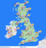
 Saturday Saturday
A westerly flow across the country, with strongest winds toward the south. Areas of showers will pass from west to east - these may locally cluster together to give frequent rain over several hours, some heavy bursts with local thunder possible. By afternoon and evening, the greatest risk of showers will be in eastern counties, whilst western areas should become brighter as pressure builds. Fresh at 17 to 22C, warmest south-east.
 Sunday Sunday
A ridge of high pressure influences much of Britain, bringing a fair day for many places, with sunshine best across the south & east. Fronts appraoching from the Atlantic bring thickening cloud to the west & north-west, and a threat of rain developing for Ireland, spreading to Scotland and areas near the Irish Sea later. Winds fairly light, but freshening south-westerlies in the west. Slightly warmer for all, highs 18 to 23C.
|
