|
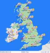
 Tuesday Tuesday
Cloudy with patchy rain during Tuesday - rain or drizzle most frequent in western areas, although amounts will be small. Central & southern England stays largely dry, with some sunshine breaking through. Early showery rain in eastern counties should clear away into the North Sea. A west to north-westerly breeze, typically strongest in the morning. Temperatures 7 to 11C, mildest in the south-west.
 Tuesday night Tuesday night
A cloudy and mild night across the country. Spots of rain mainly in western regions, but amounting to very little overall. Largely dry toward the east & south. Showers in north-west Scotland, turning to snow on the mountains. Blustery winds in the north, reaching gale force in the Western Isles. Light winds in the south. Temperatures staying between 5 and 10C for most.
 Wednesday Wednesday
A little showery rain in the south at first, but much of England & Wales will stay dry with sunny spells. Showery in Scotland - snow falling to increasingly low levels and becoming more widespread across northern Britain by evening & night. A chilly wind, strongest in the north. Starting mild in the south, briefly up to 10C, but temperatures falling to only 4 to 7C for many places by afternoon.
 Thursday Thursday
Strong west to north-westerly winds will bring frequent heavy showers to west & northern Britain. These will fall to low levels as snow or hail, giving possible accumulations and transport disruption. Isolated thunder, particularly near coasts. Central, eastern & southern counties should escape mainly dry, with sunny spells. Temperatures 2 to 6C - feeling bitterly cold in the wind.
|
